
Executive Overview
For centuries, understanding the temperament of the open sea relied on tactile observation: reading the shift of the wind, the color of the swell against the shoreline, and the unique drag of a receding tide. Long before writing a single line of code, the creator of the ARGOS coastal monitoring project spent years "reading water." Yet, the fundamental truth derived from this dual perspective—mariner and software engineer—is stark: the sea on a map and the sea breaking directly in front of you are fundamentally different objects.
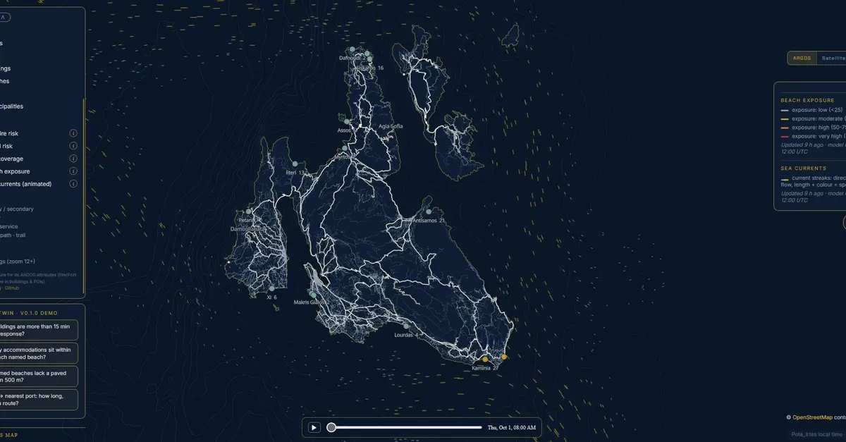
This philosophical divide forms the baseline of a major technological milestone on the Ionian island of Kefalonia. The ARGOS project has officially launched its inaugural marine layer, bringing computational forecasting to fourteen pilot beaches across the island, with a primary focus on Myrtos Beach—one of the region’s most visually deceptive coastlines. On a typical summer day, Myrtos presents as a Mediterranean paradise: brilliant white pebbles, dramatic sheer cliffs, and water that shifts seamlessly from turquoise to a deep, inviting indigo within meters of the shore. To the untrained eye, it appears to be the safest place on earth.
It is not always.
The newly deployed marine layer is designed to bridge the gap between vast offshore hydrodynamic models and localized coastal reality. However, rather than overpromising absolute safety, the system’s rollout is characterized by an uncompromising adherence to technical transparency. Operating on data pulled twice daily from the Copernicus Marine Service (CMEMS), the model evaluates offshore wave heights, directional vectors, and surface currents to compute an "exposure score" for specific coastal zones.
This article explores the architecture behind the ARGOS marine layer, examining the complex interplay of bathymetry, oceanographic modeling, and the critical admission of unvalidated parameters. It serves as an investigative look at how digital twins are attempting to decode unpredictable coastal waters, and why recognizing a model’s limits is the ultimate prerequisite for responsible technological deployment.
Detailed Chronology: The Night It Earned Its Keep
Every predictive model faces a proving ground—a specific moment where abstract calculations intersect with physical reality, validating months or years of quiet development. For ARGOS, that moment occurred on the very night the marine layer went live.
At the exact hour of deployment, the automated system logged a high-exposure score of 73.3 for Myrtos Beach, categorizing the location under a "high" exposure window spanning from 22:00 to 23:00 EEST. The underlying telemetry dictated significant wave heights reaching approximately 2 meters, driven by a directional vector of 316 degrees.
To the uninitiated, it is easy to assume these metrics were gathered by physical sensors stationed directly in the surf, bobbing in the foam at the edge of the beach. They were not.
Nothing in that computational output was measured at the shoreline. Instead, the data was computed from Copernicus Marine model datasets, processed twice a day for the fourteen pilot zones scattered across Kefalonia’s perimeter. The nearest model cells sit between 3.1 and 6.9 kilometers offshore, meaning the model speaks exclusively from the deep water, far beyond the breaker zone. What the physical beach ultimately does with that oceanic energy is not a direct measurement; it is a translation.
Understanding that distinction—that a digital model issues judgments from miles out to sea, while the coastline acts as an unpredictable translator of that force—is essential to grasping the scope of modern coastal forecasting.
Supporting Context & Metrics: The Shape of the Sea
To understand how offshore energy transforms into shoreline danger, one must look downward into the subterranean contours of the Ionian Sea. The geography of Kefalonia’s west coast creates unique hydrodynamic conditions, driven by extreme drops in bathymetry where deep water leans unusually close to the land.
Within the ARGOS EMODnet analytical window, the deepest cell plunges to an astonishing 3,841 meters. The system’s bathymetric foundation relies on EMODnet data mapped at roughly 100 meters per pixel, detailing underwater contours dropping down to 3,500 meters.
Along Myrtos Beach’s open-water bearing of 291 degrees, the corrected EMODnet contours map out a steep aquatic descent:
- 25 meters of water depth is reached roughly 2.1 kilometers from the shoreline.
- 50 meters of depth lies at 3.0 kilometers.
- 100 meters is hit at 4.2 kilometers.
- The 200-meter contour drops off approximately 10.0 kilometers offshore.
Furthermore, the specific CMEMS cell assigned to Myrtos sits 3.36 kilometers from the beach centroid, positioned comfortably between the 50-meter and 100-meter contours. At a resolution of roughly 100 meters per pixel, this provides shelf-scale context, rather than micro-targeted, swim-zone bathymetry.
This extreme geometry explains why a beach can resemble a placid swimming pool one moment and behave like an untamed energy conduit the next. Crucially, massive marine energy does not require a visible storm overhead to arrive at the shore. It merely requires a specific directional vector, a sustained wave period, and an underwater floor configured to shoal that energy precisely onto the pebbles of the coast.
The Algorithmic Layer: Waves vs. Currents
The ARGOS marine layer aggregates Copernicus Marine Mediterranean forecasts, which refresh twice daily to track wave dynamics and two-dimensional surface currents.
The core metric—the beach exposure score—is calculated using a weighted formula: a direction-gated wave score weighted at 70 percent, combined with a surface current score weighted at the remaining 30 percent.
The concept of "direction-gating" is mathematically vital. In coastal oceanography, a high wave approaching from an irrelevant or blocked direction is essentially computational noise. Conversely, a moderate wave arriving along a precise, vulnerable directional window can be the entire story of a hazard event. The model does not use the EMODnet shelf layer directly for its inner calculations; rather, the underlying CMEMS models carry their own proprietary, high-resolution bathymetry. The models understand the deep sea state, while the ARGOS infrastructure supplies the localized terrestrial geography.
Official Statements: What We Could Not Validate, So We Are Saying So
In the fast-moving world of software development and digital mapping, transparency is frequently sacrificed for marketability. Tools are often shipped with an aura of infallible authority. The team behind ARGOS chose a different, more rigorous path: admitting what they do not know.
A critical hurdle emerged during the development phase: there is no independent wave buoy deployed anywhere near Kefalonia.
The established POSEIDON marine monitoring network—the preeminent authority for Greek coastal waters—features no dedicated Kefalonia station. Its nearest named Ionian mooring is located as far south as Pylos. After extensive verification, the developers confirmed the reality of the situation: local, real-time physical validation data simply did not exist for their immediate operational zone.
Consequently, the first iteration of the ARGOS marine layer shipped unvalidated, sitting immediately at the top of the project’s validation queue.
Rather than masking this gap, the interim validation strategy relies on cross-checking model outputs against crowdsourced local reports, daily beach scoring updates from regional publications like KefaloniaPress, and the internal quality documentation bundled directly with the Copernicus products. The first draft of this project’s narrative could have concluded with a tidy, polished algorithmic success story. Instead, the developers chose the honest one.
Delimiting the Scope: What It Is Not
To prevent misinterpretation among tourists, locals, and marine operators, the ARGOS team has been explicit about what the marine layer is—and critically, what it is not:
- It is NOT a rip-current warning system. Rip currents operate on a micro-scale governed by immediate nearshore sandbar morphology that offshore models cannot resolve.
- It is NOT measured beach safety.
- It is NOT a lifeguard-grade forecast.
- It is NOT a safe-or-unsafe certification for any beach, under any circumstances.
Instead, the system is strictly defined as an exposure screening tool: a computerized translation of modeled offshore wave and current conditions into a localized beach exposure assessment. It is direction-gated, computed twice daily, presented bilingually, and explicitly public about its own operational uncertainties.
Future Outlook & The Ask
The deployment of the first marine layer on Kefalonia marks an important step forward in open-source, regional digital twin technology, but it represents the beginning of the journey rather than the destination.
A predictive model living in a server environment is only as accurate as the physical ground truth fed back into its architecture. Because institutional buoy infrastructure is absent around the island, the success of the ARGOS model moving forward relies heavily on the human element—the institutional memory held by the residents who know these waters intimately.
In an open call to the community, the project leads have turned to the local populace:
"If you are a lifeguard, a boat operator, or someone who has watched Myrtos for thirty years: your observations are the validation this layer is missing. The map will only get as honest as the ground truth it is fed."
Built directly in Kefalonia by locals watching over the places they call home, the project invites public collaboration and technical scrutiny. As the model continues to ingest real-world observations, cross-reference historical data sets, and refine its directional gating algorithms, it stands as a testament to the power of community-driven technological humility.
The digital twin cannot replace the wisdom of the mariner, but by acknowledging its own limits, it strives to become a valuable companion for those who look out at the Ionian Sea and seek to understand its depths.
Built in Kefalonia. Watching over the places we call home.
Project Links & Resources: