

Executive Overview
As the Atlantic hurricane season reaches its traditionally volatile mid-point, coastal communities from Maine to Texas find themselves experiencing an uncanny and historically rare meteorological stillness. While calendars mark the peak months of tropical cyclone development, the Atlantic basin remains remarkably dormant. Since the official start of the season in June, the region has produced only three named storms—a fragile, short-lived trio of weak tropical systems that struggled to maintain structural integrity against an overwhelming wall of hostile atmospheric and oceanic barriers.
Meteorologists and climate scientists are currently tracking one of the quietest Atlantic hurricane seasons in over a decade. Forecasters now project fewer than ten named storms for the entirety of the 2026 cycle. To put this dormancy into perspective, the Accumulated Cyclone Energy (ACE) index—a metric used by forecasters to calculate the combined intensity and longevity of tropical storms and hurricanes—typically registers an average baseline of 122.5 by the end of a standard season. As of mid-August, the entire Atlantic basin has generated a meager ACE of just 3.1, hovering at roughly 23 percent of normal levels for this time of year.
This unprecedented atmospheric suppression is not the result of a single anomaly, but rather a rare convergence of powerful global climatic forces. At the heart of this suppression is a historically intense El Niño event that has materialized with shocking velocity across the Pacific Ocean, shattering long-term records. Operating in tandem with this super-charged El Niño are persistent plumes of dry, dust-laden air blowing off the Sahara Desert and a subdued West African monsoon cycle.
Yet, beneath the umbrella of this broader statistical quietude lies a critical caveat underscored by historical precedent: a suppressed season does not guarantee total safety. Climatologists warn that El Niño years, despite their general suppression of overall storm numbers, remain fully capable of spawning catastrophic, high-impact landfalling hurricanes. Coastal residents are urged to view this temporary reprieve not as an all-clear, but as a crucial window for disaster preparedness.
Detailed Chronology: The Evolution of a Dormant Basin
The trajectory of the 2026 Atlantic hurricane season began to deviate from historical norms early in the spring, as pre-season sea surface temperature anomalies in the Pacific began to cascade through global weather models.
June: A Sluggish and Disheveled Start
The Atlantic hurricane season officially commenced on June 1, but the opening weeks lacked the standard atmospheric catalysts required to spark organized tropical cyclogenesis. Typically, early-season activity spins up in the Gulf of Mexico or the western Caribbean Sea, fueled by warm local waters and early atmospheric moisture. In June 2026, however, the basin produced only faint, disorganized pulses of weather. The systems that did form were quickly torn apart by premature upper-level wind shear streaming across the equator from the Pacific.
July: The Mid-Summer Stall
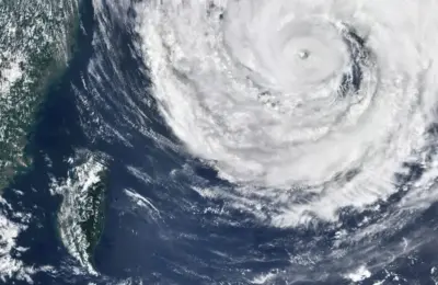
By July, when activity should have begun its characteristic ramp-up toward the Cape Verde season—where major storms typically march off the coast of Africa—the Atlantic encountered a brick wall of dry air. Plumes of Saharan dust, carried aloft by continental winds, surged thousands of miles westward across the tropical Atlantic. This layer of warm, dry air acted as an atmospheric lid, effectively suffocating nascent thunderstorms before they could harness the latent heat of the ocean surface. While the western Pacific experienced a hyper-active typhoon season that shattered records, the Atlantic remained structurally sterile.
August: The Peak That Never Was
As the calendar turned to August—the gateway to the climatological peak of the hurricane season—forecasters anticipated at least a slight seasonal correction. Instead, the stifling combination of an intensifying El Niño, a lethargic West African monsoon, and persistent Saharan dust intrusions locked the basin into place. Only a single weak tropical storm managed to organize during the early weeks of the month. Tropical Storm Arthur, despite its structurally disheveled appearance and overall lack of basin-wide power, demonstrated the deceptive nature of "weak" storms by parking over Louisiana and dumping an astonishing 29 inches of rain near Cottonport, threatening to rewrite the state’s 24-hour precipitation records.
Supporting Context & Metrics: The Mechanics of Suppression
To understand why the Atlantic basin has transformed into a graveyard for tropical systems, one must examine the macro-level climatic drivers currently rewriting global weather patterns.
The Super El Niño of 2026
The primary engine driving the Atlantic’s quietude is an exceptionally potent El Niño event that has stunned researchers with its rapid intensification throughout the summer. El Niño is characterized by warmer-than-normal waters pooling across the central and eastern equatorial Pacific Ocean. Officially, an El Niño event requires water temperatures in this critical region to run at least 0.5 degrees Celsius (0.9 degrees Fahrenheit) above normal for several consecutive months.
Measurements recorded in the summer of 2026, however, have obliterated baseline thresholds. Swaths of the eastern and central Pacific are currently recording sea surface temperatures at least 1.5 degrees Celsius above average, with isolated sub-regions displaying astonishing localized anomalies reaching up to 4 degrees Celsius above normal. This places the current event on a trajectory to rank as one of the strongest El Niño episodes in over 150 years of record-keeping.
The Physics of Wind Shear
The mechanism by which a Pacific-based phenomenon suppresses Atlantic hurricanes is rooted in atmospheric dynamics. Abnormally warm waters in the equatorial Pacific trigger massive columns of rising air (convection). This intense localized heating alters upper-level wind patterns on a planetary scale.
As the upper-level winds adjust, they generate powerful, persistent eastward-flowing winds across the Caribbean and the tropical Atlantic—a meteorological phenomenon known as vertical wind shear. Tropical cyclones rely on a vertically aligned structure to vent heat and moisture from their cores. When severe wind shear tears across the Atlantic, it strips the tops off budding thunderstorms, preventing them from organizing into closed circulations and stifling their development into tropical depressions or hurricanes.
The West African Monsoon and Saharan Air Layer (SAL)
While El Niño pulls the strings from the Pacific, regional African weather patterns are reinforcing the suppression. The West African monsoon is normally responsible for generating robust atmospheric disturbances—known as African easterly waves—that move off the coast and serve as the foundational seeds for many of the Atlantic’s most powerful hurricanes.
In 2026, the West African monsoon has underperformed significantly. Below-average rainfall totals recorded across nations such as Sierra Leone and Guinea indicate a marked reduction in the vigor of these foundational atmospheric disturbances.
Compounding this issue is the Saharan Air Layer (SAL). Vast expanses of dry, dust-laden air routinely sweep off the African continent, but the frequency and intensity of these dry-air injections during the summer of 2026 have been extraordinary. The dust particles absorb solar radiation and create stable atmospheric layers that inhibit cloud formation, while the dry air desiccates any moisture attempting to pool in the lower and middle troposphere.
Official Statements and Scientific Consensus
Atmospheric scientists and hurricane forecasters have spent the summer analyzing the confluence of these extreme anomalies.
"We are witnessing a textbook example of global teleconnections at work," notes Dr. Elena Vance, a senior climate dynamicist specializing in tropical meteorology. "The sheer thermal energy stored in the equatorial Pacific this year is extraordinary. It is effectively acting as a global thermostat, dialing up extreme typhoon activity in the western Pacific while throwing a wet blanket over the Atlantic basin. The combination of high shear, dry Saharan air, and a weak African monsoon has created a near-impenetrable defensive barrier against tropical development."
Federal and academic forecasting centers have progressively dialed down their seasonal predictions. In updated advisories, meteorologists emphasize that the current metrics point toward the least active Atlantic season since 2013.
However, official warnings consistently carry an urgent caveat: statistical probability is not a guarantee. Dr. Marcus Vance, a lead hurricane specialist, emphasizes that the public must not confuse a quiet season with a harmless one. "When we look at accumulated cyclone energy values sitting at just 23 percent of normal for mid-August, it is easy to assume coastal vulnerabilities are temporarily suspended," he stated in a recent meteorological briefing. "History tells us a very different story. Some of the most devastating, rapid-intensification hurricanes in the historical record formed during prominent El Niño years."
Future Outlook: The Paradox of El Niño Hurricanes
As the 2026 hurricane season progresses past its historical peak and looks toward the autumn months, forecasters are urging communities to maintain a high state of readiness.
The paradox of El Niño-inhibited hurricane seasons is well-documented in meteorological archives. While the overall number of storms drops precipitously, the environmental factors that suppress the weak systems do not entirely eliminate the localized pockets of warm water and favorable atmospheric windows that can allow a rogue storm to explode in intensity.
Historical precedent validates this concern. Several infamous, highly destructive hurricanes struck during active El Niño cycles, including:
- Hurricane Camille (1969): A catastrophic Category 5 storm that devastated the Mississippi coast.
- Hurricane Ivan (2004): A long-lived, extremely powerful Cape Verde hurricane that wrought widespread destruction across the Caribbean and the United States Gulf Coast.
- Hurricane Charley (2004): A compact, fiercely intense storm that rapidly intensified before slamming into southwest Florida.
- Hurricane Michael (2018): A late-season Category 5 monster that intensified explosively right up until landfall in the Florida Panhandle.
- Hurricane Idalia (2023) and Hurricane Lee (2023): Recent examples proving that severe impacts can occur even when overarching seasonal dynamics present complex challenges.
Furthermore, while the Atlantic remains subdued, the Pacific basins are experiencing heightened activity. The western Pacific typhoon season has surged ahead at a pace unseen in nearly fifty years, marked by multiple Category 5-equivalent storms including Sinlaku, Bavi, Dolphin, and Genevieve. Meanwhile, the central and eastern Pacific basins are tracking above-average activity, signaling that global tropical energy has merely been redistributed rather than destroyed.
Preparedness in an Era of Extremes
For coastal residents, the takeaway from the quiet 2026 Atlantic season is nuanced. The atmospheric hurdles currently choking out tropical storms are formidable, but they are not permanent fixtures. As autumn approaches, localized shifts in sea surface temperatures or temporary lulls in wind shear could open a brief, dangerous corridor for storm development.
Emergency management agencies stress that disaster planning should never be calibrated to a single season’s forecast. The infrastructure of preparedness—evacuation routes, emergency supply kits, home hardening, and insurance reviews—must remain robust regardless of whether a season features thirty storms or three. In a climate system undergoing rapid and profound shifts, complacency remains the single greatest hazard facing coastal populations.