

Executive Overview
The architecture of modern geopolitics is rapidly extending beyond Earth’s atmosphere, transforming the silent, vacuum-sealed expanse of low-Earth orbit (LEO) and geosynchronous orbit (GEO) into a contested geopolitical chessboard. The publication of an unclassified Defense Intelligence Agency (DIA) assessment on space threats has brought this invisible theater into sharp focus, offering the public a rare, high-resolution glimpse into the clandestine capabilities of the world’s leading space-faring powers.
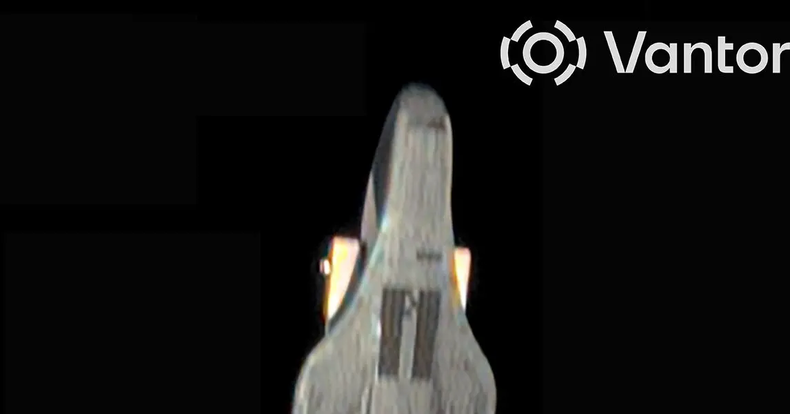
At the center of this new intelligence release is a historic piece of orbital photography: a crisp, highly detailed image of China’s clandestine, winged spaceplane captured in orbit by a commercial imaging satellite operated by Vantor (formerly known as Maxar) in 2024. This visual evidence confirms what intelligence analysts have long suspected—that Beijing has engineered an autonomous, reusable spaceplane heavily modeled after the United States Space Force’s iconic X-37B.
However, the implications of this imagery stretch far beyond cosmetic similarities in aerospace design. The DIA assessment underscores an accelerating global arms race in space, characterized by non-Earth imaging (NEI), orbital rendezvous and proximity operations (RPO), directed-energy weapons (DEWs), and the normalization of offensive counterspace technologies. As superpowers race to secure dominance in the high frontier, the boundary between peaceful commercial space exploration and aggressive military counter-space operations has evaporated.
Detailed Chronology: The Evolution of the Shadow Fleet
The clandestine cat-and-mouse game unfolding hundreds of miles above our heads is rooted in decades of aerospace development, punctuated by secretive rocket launches, sudden orbital intercepts, and technological leapfrogging between Washington and Beijing.
2000s–2020: The Genesis of the Shenlong and the X-37B
While the United States military began flying its unpiloted Boeing X-37B Orbital Test Vehicle (OTV) in 2010—racking up cumulative missions lasting thousands of days—China was quietly laying the groundwork for its own indigenous reusable platform. Western defense analysts frequently tracked early reports regarding the "Shenlong" (Divine Dragon), a robotic spaceplane project pursued by Chinese defense contractors since the mid-2000s.
2020–2024: China’s Rapid Flight Cadence
China officially entered the operational spaceplane arena in September 2020 with the launch of its first reusable experimental spacecraft, referred to in Chinese state media simply as Chongfu Shiyong Shiyan Hangtian Qi (CSSHQ). This inaugural flight was short-lived, lasting just two days, but it signaled a massive leap in Beijing’s ambitions.
Subsequent missions scaled up dramatically in complexity and duration:
- The Second and Third Missions: China launched successive long-duration flights, testing autonomous thermal protection systems, deployment mechanisms, and orbital maneuvering.
- The Fourth Mission (2024–Present): Launched in February 2024, this mission pushed technological boundaries even further. Open-source orbital tracking data analyzed by astrophysicist Jonathan McDowell revealed a striking capability: in June and July, and again in August and September, the CSSHQ deployed a sub-satellite into orbit, successfully recaptured or interacted with it—likely utilizing an onboard robotic arm—and then repeated the cycle. This "catch and release" maneuver demonstrates sophisticated proximity operations that mirror capabilities traditionally reserved for satellite servicing, but with clear dual-use military applications such as orbital asset interference or capture.
2024: The Maxar/Vantor Breakthrough
The turning point for public transparency occurred in 2024 when a commercial Earth-imaging satellite owned by Maxar (now Vantor) trained its high-powered optical telescopes upward rather than downward. By leveraging Non-Earth Imaging (NEI) techniques during a high-speed, chance orbital intercept, the commercial satellite snapped a pristine, high-resolution photograph of the Chinese spaceplane gliding through the blackness of LEO.
Though a lower-resolution DIA assessment referenced the event and a U.S. Space Force official briefly touched upon it during a conference in South Korea, the full-resolution image remained under wraps until its official publication in the unclassified DIA threat assessment.
Supporting Context & Metrics: Comparing Spaceplanes and Counterspace arsenals
To understand the strategic gravity of these developments, it is necessary to examine the physical parameters, operational profiles, and technological metrics that define the U.S. and Chinese reusable spaceplane programs, alongside broader counterspace threats.
Structural and Operational Comparison
| Metric / Feature | U.S. Space Force (X-37B OTV) | China’s CSSHQ (Reusable Spaceplane) |
|---|---|---|
| Primary Operator | Department of the Air Force / Space Force | People’s Liberation Army Strategic Support Force / Aerospace entities |
| Builder | Boeing | State-owned aerospace contractors (CASC/CASIC) |
| Launch Method | Encapsulated in a conventional rocket payload fairing (Atlas V, Falcon Heavy) | Encapsulated in a Long March rocket payload fairing |
| Landing Method | Autonomous runway landing (Shuttle-style) | Autonomous runway landing (Shuttle-style) |
| Maximum Mission Duration | Up to 908 days (approx. 2.5 years) | Up to 9 months per mission (iterative growth) |
| Orbital Reach | Low-Earth Orbit (LEO) up to deep elliptical orbits exceeding 24,000 miles | Low-Earth Orbit (LEO), typically a few hundred miles high |
| Advanced Capabilities | Classified experiments, smallsat deployment, aerodynamic aerobraking | Smallsat deployment, robotic arm capture/release ("catch and release") |
The Mechanics of Non-Earth Imaging (NEI)
The capture of the CSSHQ image highlights an emerging frontier in intelligence gathering: Non-Earth Imaging (NEI). Traditionally, reconnaissance satellites point their sophisticated optics downward to observe foreign ICBM silos, naval fleets, and troop movements.
NEI flips this paradigm upside down. By programming commercial and military Earth-observation satellites to track targets moving across the stellar background, analysts can perform forensic inspections of classified foreign spacecraft. These observations happen during split-second, high-speed orbital intersections. Unlike deliberate rendezvous and proximity operations (RPO)—where a pursuer actively matches orbits to trail an adversary—NEI relies on opportunistic geometry, turning commercial remote-sensing infrastructure into vital strategic intelligence nodes.
Counterspace Vectors: Lasers, Missiles, and Stalker Satellites
Beyond spaceplanes, the DIA threat assessment paints a sobering picture of China’s comprehensive "counterspace" arsenal designed to neutralize American space dominance:
- Directed-Energy Weapons (DEWs): The DIA reports that China views ground-based lasers as "ideal counterspace systems." Beijing currently operates multiple ground-based laser installations capable of dazzling, temporarily disrupting, or permanently damaging sensitive optical sensors on LEO satellites. By the late 2020s, China is projected to field space-based DEWs and higher-powered ground systems capable of threatening assets in higher orbital regimes, such as Medium Earth Orbit (MEO) and GEO.
- Orbital Interceptors and Proximity Operators: China has demonstrated advanced robotic arm technologies and operates a growing constellation of TJS ("Tongxin Jishu Shiyan") satellites designed to routinely shadow and approach foreign spacecraft in geosynchronous orbit—an altitude roughly 22,000 miles above the Earth where critical communication and early-warning satellites reside.
Official Statements and Strategic Doctrines
The release of the DIA threat assessment is not merely an exercise in academic transparency; it is a calculated signaling campaign by the Pentagon to alert lawmakers, allies, and the public to the shifting balance of power in orbit.
Speaking on the proliferation of space weapons, defense officials have grown increasingly vocal about the militarization of the cosmos. The traditional post-Cold War consensus that kept space as a sanctuary for science and telecommunications has shattered.
"The enhanced maneuverability of spaceplanes makes them more suitable for certain missions than traditional satellites," the DIA stated in its public assessment, emphasizing that autonomous aerodynamic control allows these vehicles to alter orbital planes, dip into the upper atmosphere for trajectory adjustments, and avoid predictable tracking patterns.
This sentiment is matched by rapid shifts in American doctrine. In a historic admission, Air Force Secretary Troy Meink confirmed that the Pentagon has officially deployed weapons in space—positioning the United States as the first nation to publicly acknowledge an armed orbital posture. This capability is paired with a growing constellation of U.S. Space Force inspector satellites and refuelable spacecraft designed to outmaneuver foreign stalkers.
Meanwhile, the threat matrix is compounded by Russian activities. U.S. intelligence officials continue to warn of Moscow’s parallel ambitions to deploy nuclear weapons in orbit, alongside conventional counterspace systems like the Nivelir program. Demonstrating this operational hazard, a Russian inspection satellite (Kosmos 2612 and related smallsats) maneuvered within "tens of meters" of a commercial radar remote-sensing satellite owned by ICEYE—a platform providing crucial reconnaissance data to Ukraine—before backing away, illustrating how terrestrial conflicts are now directly tethered to orbital intimidation.
Future Outlook: The Next Frontier of Conflict
As the decade progresses, the trajectory of space exploration and military competition points toward an increasingly crowded, aggressive, and unpredictable environment.
The convergence of reusable spaceplanes, autonomous robotic manipulation, directed-energy weapons, and commercial NEI means that low-Earth orbit is no longer a vast, empty wilderness. Instead, it has become a tightly monitored, friction-heavy operational zone where every satellite launch is scrutinized for hostile intent.
For the United States and its allies, the challenge lies in deterring aggression in a domain where attribution is notoriously difficult, weapon deployment is invisible to the naked eye, and the kinetic consequences of an orbital clash could cascade into a Kessler Syndrome disaster—rendering vital orbital bands unusable for generations.
The crisp, high-resolution photograph of the Chinese spaceplane captured by a commercial eye in the sky is likely only the beginning. As space imaging technology sharpens and military budgets pivot toward space-domain awareness, the veil of secrecy surrounding the high frontier is permanently lifting, exposing an arms race that will define the security paradigm of the 21st century.